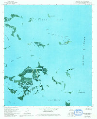
1973 Map of Black Bay South
USGS Topo · Published 1992About this map
West Black Bay Oil and Gas Field dominates the aquatic landscape of this coastal Plaquemines Parish region, where industry meets the complex marshlands of the Mississippi River Delta. This orthophotomap, based on aerial photography from the early 1970s, captures the delicate balance between natural waterways like Whiskey Bay and Lost Bayou and the human footprint of resource extraction, represented by numerous Platform structures and a Radio Tower on Stone Island. The terrain is a maze of islands and passes, including Belle Isle and Lonesome Island, separated by wide expanses such as Bay Crabe and California Bay. To the east, the map opens into the vast Breton Sound, marked at its edge by Telegraph Point. The intricate network of tidal channels like Bel Pass reflects a dynamic ecosystem where land and water are constantly in flux.
Find a feature on this map
19 named features on this map. Tap any name to fly to it.
Don’t see what you’re looking for? This feature index may not catch every label — zoom into the map to look around manually.
Map Details
Editions of this 1973 Black Bay South Map
2 editions found
Other maps of this area

1892 · Quarantine
USGS Topo · 1:62,500

1893 · La Fortuna
USGS Topo · 1:62,500

1893 · Forts
USGS Topo · 1:62,500

1893 · Dime
USGS Topo · 1:62,500

1935 · Port Sulphur
USGS Topo · 1:31,680

1935 · Lake Athanasio
USGS Topo · 1:31,680

1935 · Lake Calebasse
USGS Topo · 1:31,680

1935 · Tropical Bend
USGS Topo · 1:31,680

1941 · Black Bay
USGS Topo · 1:62,500

1941 · Empire
USGS Topo · 1:62,500