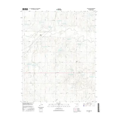
2016 Map of Black Bear
USGS Topo · Published 2016About this map
Black Bear sits amidst a network of watershed management features and rural infrastructure in this Oklahoma landscape. The area is defined by the winding course of Black Bear Cr and a dense collection of reservoirs, including Upper Black Bear Cr Site 11 Reservoir and Upper Black Bear Cr Site 15 Reservoir, which illustrate modern land use and water control strategies. The terrain rises to Knob Hill, overlooking a grid of local roads named for both local figures and cultural themes, such as John Wayne and Independence. Cultural history is preserved at the Bohemian Catholic Cem and Zion Cem, while the southern reaches near Richburg Cem are drained by small tributaries like Mule Cr and Willow Cr. This 2016 survey documents the enduring agricultural character of Noble County through its persistent rural cemeteries and systematic water conservation sites.
Find a feature on this map
52 named features on this map. Tap any name to fly to it.
Don’t see what you’re looking for? This feature index may not catch every label — zoom into the map to look around manually.
Map Details
Editions of this 2016 Black Bear Map
This is the sole edition of this map. No revisions or reprints were ever made.
Other maps of this area

1893 · Mulhall
USGS Topo · 1:62,500

1893 · Stillwater
USGS Topo · 1:62,500

1955 · Enid
USGS Topo · 1:250,000

1958 · Enid
USGS Topo · 1:250,000

1966 · Lake Carl Blackwell
USGS Topo · 1:24,000
1967 · Stillwater North
USGS Topo · 1:24,000

1972 · Morrison NE
USGS Topo · 1:24,000

1972 · Morrison
USGS Topo · 1:24,000

1972 · Red Rock
USGS Topo · 1:24,000

1972 · Ceres
USGS Topo · 1:24,000