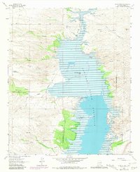
1961 Map of Black Bluffs
USGS Topo · Published 1981About this map
Elephant Butte Reservoir dominates this high-desert landscape, where the waters of the Rio Grande pool north of the dam. The map details the complex geography of the shoreline, from the constricted passage at The Narrows to prominent landmarks like North Monticello Point and Three Sisters Point. Evidence of ranching and land use is visible throughout the arid canyons, including Elkins Ranch and the Chavez Windmill near Alamosa Creek.
Find a feature on this map
39 named features on this map. Tap any name to fly to it.
Don’t see what you’re looking for? This feature index may not catch every label — zoom into the map to look around manually.
Map Details
Editions of this 1961 Black Bluffs Map
4 editions found
Other maps of this area

1954 · Tularosa
USGS Topo · 1:250,000

1958 · Tularosa
USGS Topo · 1:250,000

1958 · Elephant Butte
USGS Topo · 1:24,000

1959 · Engle
USGS Topo · 1:62,500

1961 · Huerfano Hill
USGS Topo · 1:24,000

1961 · Sierra Fijardo
USGS Topo · 1:24,000

1961 · Black Bluffs
USGS Topo · 1:24,000

1961 · Crocker
USGS Topo · 1:24,000

1961 · Lava
USGS Topo · 1:24,000

1961 · Cuchillo
USGS Topo · 1:24,000