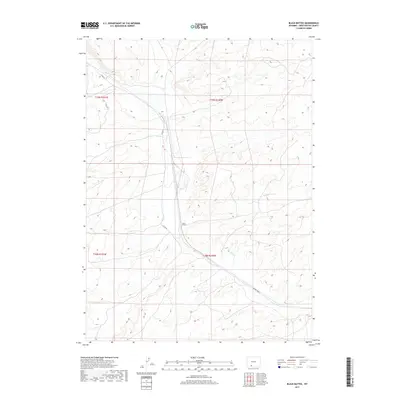
2017 Map of Black Buttes
USGS Topo · Published 2017About this map
Black Buttes sits at a geographic crossroads in this 2017 study of Sweetwater County, where the high desert landscape is defined by the winding course of Bitter Cr. The drainage of Bitter Creek serves as the primary topographic anchor for the region, carving through a series of ridges and valleys that dictate the local infrastructure. The primary thoroughfare, Co Rd 84, mirrors the waterway's path, illustrating how modern transportation corridors in this part of Wyoming continue to follow the natural contours established by prehistoric erosion. This quadrangle captures the intersection of several townships, including t19n r100w and t18n r100w, providing a clear record of the Public Land Survey System grid as it overlays the arid terrain of the Great Divide Basin vicinity.
Find a feature on this map
8 named features on this map. Tap any name to fly to it.
Don’t see what you’re looking for? This feature index may not catch every label — zoom into the map to look around manually.
Map Details
Editions of this 2017 Black Buttes Map
This is the sole edition of this map. No revisions or reprints were ever made.
Other maps of this area

1954 · Rock Springs
USGS Topo · 1:250,000

1958 · Rock Springs
USGS Topo · 1:250,000

1962 · Rock Springs
USGS Topo · 1:250,000

1968 · Cooper Ridge NE
USGS Topo · 1:24,000

1968 · Bitter Creek NW
USGS Topo · 1:24,000

1968 · Sand Butte Rim NW
USGS Topo · 1:24,000

1968 · Bitter Creek
USGS Topo · 1:24,000

1968 · Black Buttes
USGS Topo · 1:24,000

1968 · Point Of Rocks
USGS Topo · 1:24,000
1968 · Point Of Rocks SE
USGS Topo · 1:24,000