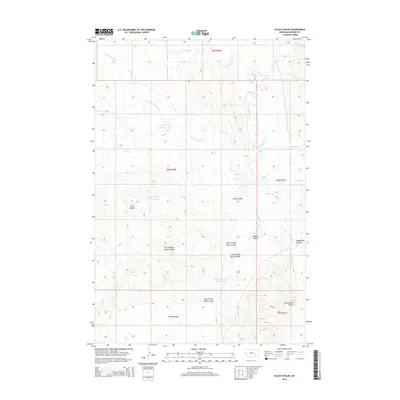
2014 Map of Black Coulee
USGS Topo · Published 2014About this map
Schoolmarm Buttes anchor the southeastern corner of this Rosebud County landscape, rising above a network of drainages that define the local topography. This 2014 survey by the U.S. Geological Survey captures the complex drainage systems of the region, where Little Porcupine Cr and Stellar Cr flow through the northern reaches. The land is marked by numerous seasonal and permanent water catchments, including the Hay Cr Reservoir, Corny Coulee Reservoir, and Black Coulee Reservoir. These features, along with the distinct naming of landforms like Wagon Box Coulee and North Prong Black Coulee, reflect the historical reliance on specific landmarks and water sources in this part of Montana. The map provides a detailed view of the Public Land Survey System divisions, illustrating the township and range grid that continues to organize this rural territory.
Find a feature on this map
20 named features on this map. Tap any name to fly to it.
Don’t see what you’re looking for? This feature index may not catch every label — zoom into the map to look around manually.
Map Details
Editions of this 2014 Black Coulee Map
This is the sole edition of this map. No revisions or reprints were ever made.
Other maps of this area

1954 · Forsyth
USGS Topo · 1:250,000

1957 · Forsyth
USGS Topo · 1:250,000

1958 · Forsyth
USGS Topo · 1:250,000

1968 · Orinoco
USGS Topo · 1:24,000

1968 · Nichols
USGS Topo · 1:24,000

1968 · Forsyth
USGS Topo · 1:24,000

1968 · Schultz Coulee
USGS Topo · 1:24,000

1968 · Finch NE
USGS Topo · 1:24,000

1968 · Black Coulee
USGS Topo · 1:24,000
1969 · Rough Creek SE
USGS Topo · 1:24,000