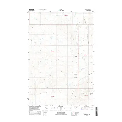
2017 Map of Black Coulee
USGS Topo · Published 2017About this map
Schoolmarm Buttes anchor the southeastern corner of this Rosebud County landscape, characterized by a series of drainage coulees and seasonal water catchments. The drainage network is complex, with North Prong Black Coulee and South Prong Black Coulee converging as they feed toward the east. This 2017 survey reveals the reliance on small-scale water management in this semi-arid region, evidenced by the Hay Cr Reservoir, Corny Coulee Reservoir, and Black Coulee Reservoir. The area is largely defined by its natural topography, with few man-made structures beyond Little Porcupine Creek Rd, which tracks alongside Little Porcupine Cr. Other notable landforms include the distinctively named Wagon Box Coulee and the winding course of Stellar Cr in the northern townships.
Find a feature on this map
21 named features on this map. Tap any name to fly to it.
Don’t see what you’re looking for? This feature index may not catch every label — zoom into the map to look around manually.
Map Details
Editions of this 2017 Black Coulee Map
This is the sole edition of this map. No revisions or reprints were ever made.
Other maps of this area

1954 · Forsyth
USGS Topo · 1:250,000

1957 · Forsyth
USGS Topo · 1:250,000

1958 · Forsyth
USGS Topo · 1:250,000

1968 · Orinoco
USGS Topo · 1:24,000

1968 · Nichols
USGS Topo · 1:24,000

1968 · Forsyth
USGS Topo · 1:24,000

1968 · Schultz Coulee
USGS Topo · 1:24,000

1968 · Finch NE
USGS Topo · 1:24,000

1968 · Black Coulee
USGS Topo · 1:24,000
1969 · Rough Creek SE
USGS Topo · 1:24,000