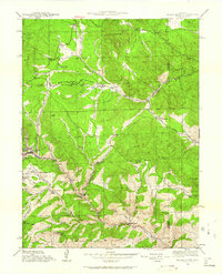
1942 Map of Black Hawk
USGS Topo · Published 1962About this map
Black Hawk anchors this 1942 survey, situated at the confluence of several gulches where mining and mountain topography dictate the local geography. The map captures the transition from the concentrated urban density of the Central City boundary and the industrial footprint of the Summit Mine to the remote ranching and forest lands of the Front Range. Named gulches like Chase Gulch, Russell Gulch, and Fourmile Gulch create a complex drainage network feeding into North Clear Creek and Ralston Creek.
Find a feature on this map
38 named features on this map. Tap any name to fly to it.
Don’t see what you’re looking for? This feature index may not catch every label — zoom into the map to look around manually.
Map Details
Editions of this 1942 Black Hawk Map
4 editions found

Other maps of this area

1899 · West Denver
USGS Topo · 1:125,000

1903 · Georgetown
USGS Topo · 1:62,500

1905 · Central City
USGS Topo · 1:62,500

1905 · Georgetown
USGS Topo · 1:62,500

1906 · Blackhawk
USGS Topo · 1:62,500

1910 · Central City
USGS Topo · 1:62,500

1912 · Central City
USGS Topo · 1:62,500

1942 · Eldorado Springs
USGS Topo · 1:24,000

1942 · Nederland
USGS Topo · 1:24,000

1942 · Central City
USGS Topo · 1:24,000