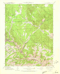
1942 Map of Black Hawk
USGS Topo · Published 1966About this map
Black Hawk and the neighboring eastern edge of Central City sit at the heart of this 1942 topographical survey, revealing the high-elevation mining and ranching landscape of Gilpin County. The map provides a detailed view of the drainage systems and steep gulches that shaped the region's development, including Russell Gulch, Chase Gulch, and Fourmile Gulch. Rural education and agricultural life are represented by the Mountain House Sch and Bay State Sch, while the presence of the Summit Mine near Elkhorn Gulch underscores the area's industrial roots. The terrain transitions from the protected timber of the Roosevelt National Forest in the northwest down toward the canyon corridors of North Clear Creek. Significant landmarks like Black Hawk Mountain and Tremont Mtn overlook a network of mountain thoroughfares, including the Golden Gate Canyon Road and Crawford Gulch Road, which linked these remote mining camps to the wider Colorado territory.
Find a feature on this map
40 named features on this map. Tap any name to fly to it.
Don’t see what you’re looking for? This feature index may not catch every label — zoom into the map to look around manually.
Map Details
Editions of this 1942 Black Hawk Map
4 editions found

Other maps of this area

1899 · West Denver
USGS Topo · 1:125,000

1903 · Georgetown
USGS Topo · 1:62,500

1905 · Central City
USGS Topo · 1:62,500

1905 · Georgetown
USGS Topo · 1:62,500

1906 · Blackhawk
USGS Topo · 1:62,500

1910 · Central City
USGS Topo · 1:62,500

1912 · Central City
USGS Topo · 1:62,500

1942 · Eldorado Springs
USGS Topo · 1:24,000

1942 · Nederland
USGS Topo · 1:24,000

1942 · Central City
USGS Topo · 1:24,000