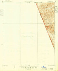
1938 Map of Black Mountain
USGS Topo · Published 1948About this map
The wild, high-altitude landscape of the Los Padres National Forest dominates the eastern portion of this survey, which captures the sharp transition between Los Angeles and Ventura counties. Topography here is defined by the steep drainage of Piru Creek, which flows through a complex network of ridges and narrow valleys. This specific sheet focuses on the eastern margin of the broader Tejon region, where the terrain rises toward Dome Mtn and descends into the deep cuts of Beartrap Canyon. A solitary Spring is noted near the canyon floor, a vital resource in this arid, high-elevation environment. The lack of roads or settlements emphasizes the undeveloped character of these mountains in the early 1930s, showing the land before modern infrastructure began to penetrate these remote sections of the Transverse Ranges.
Find a feature on this map
7 named features on this map. Tap any name to fly to it.
Don’t see what you’re looking for? This feature index may not catch every label — zoom into the map to look around manually.
Map Details
Editions of this 1938 Black Mountain Map
3 editions found
Other maps of this area

1903 · Tejon
USGS Topo · 1:125,000

1931 · Whitaker Peak
USGS Topo · 1:24,000

1932 · Beartrap Canyon
USGS Topo · 1:24,000

1933 · Quail
USGS Topo · 1:24,000

1933 · Gorman
USGS Topo · 1:24,000

1935 · Whitaker Peak
USGS Topo · 1:24,000

1938 · Beartrap Canyon
USGS Topo · 1:24,000

1938 · Gorman
USGS Topo · 1:24,000

1938 · Black Mountain
USGS Topo · 1:24,000

1938 · Quail
USGS Topo · 1:24,000