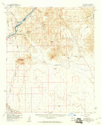
1959 Map of Black Peak
USGS Topo · Published 1961About this map
The Colorado River forms the vital western boundary of this desert landscape, separating San Bernardino County, California, from the Colorado River Indian Reservation in Arizona. At the close of the 1950s, the region was defined by a heavy industrial footprint in the Buckskin Mountains, where a network of prospects and claims like the Mineral Hill Mines, Mammon Mine, and Billy Mack Mine punctuate the arid peaks.
Find a feature on this map
50 named features on this map. Tap any name to fly to it.
Don’t see what you’re looking for? This feature index may not catch every label — zoom into the map to look around manually.
Map Details
Editions of this 1959 Black Peak Map
4 editions found
Other maps of this area

1911 · Parker
USGS Topo · 1:125,000

1923 · Signal
USGS Topo · 1:250,000

1930 · Linskey
USGS Topo · 1:62,500

1931 · Moon Mtn
USGS Topo · 1:62,500

1932 · Moon Mtn
USGS Topo · 1:62,500

1942 · Signal
USGS Topo · 1:250,000

1942 · Blythe
USGS Topo · 1:250,000

1942 · Vicksburg
USGS Topo · 1:250,000

1942 · MOON MTN
USGS Topo · 1:62,500

1943 · Giers Basin
USGS Topo · 1:62,500