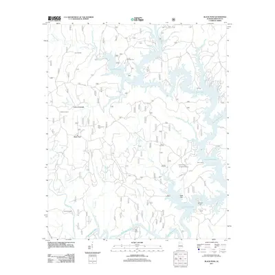
2011 Map of Black Pond
USGS Topo · Published 2011About this map
Lewis Smith Lake dominates this portion of Winston County, its sprawling shoreline reaching deep into the landscape via the Sipsey Fork and Clear Creek. The impoundment surrounds the historic site of Falls City, creating a network of peninsulas where local history is preserved in small family and community burial grounds. Avery Cemetery, Wilson Cemetery, and Bennett Cemetery are scattered throughout the hills, providing valuable markers for genealogists researching the families of this river-cut terrain.
Find a feature on this map
64 named features on this map. Tap any name to fly to it.
Don’t see what you’re looking for? This feature index may not catch every label — zoom into the map to look around manually.
Map Details
Editions of this 2011 Black Pond Map
This is the sole edition of this map. No revisions or reprints were ever made.
Other maps of this area

1893 · Jasper
USGS Topo · 1:125,000

1949 · Manchester
USGS Topo · 1:24,000

1949 · Nauvoo
USGS Topo · 1:24,000

1949 · Sunlight
USGS Topo · 1:24,000

1950 · Nauvoo
USGS Topo · 1:24,000

1950 · Manchester
USGS Topo · 1:24,000
1951 · Sunlight
USGS Topo · 1:24,000

1953 · Birmingham
USGS Topo · 1:250,000

1956 · Birmingham
USGS Topo · 1:250,000

1956 · Gadsden
USGS Topo · 1:250,000