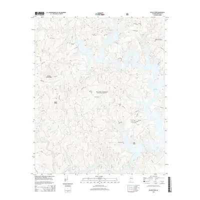
2014 Map of Black Pond
USGS Topo · Published 2014About this map
Lewis Smith Lake dominates the eastern half of this Winston County landscape, its sprawling shoreline creating a complex series of inlets and coves that reach into the surrounding forest. The map reveals the intricate drainage system of the area, where waterways like Clear Creek, Caney Cr, and Hoghouse Cr flow through the deeply dissected terrain of the William B. Bankhead National Forest. This 2014 survey documents a region characterized by small, dispersed settlements and a high density of family and community burial grounds, illustrating the persistent rural social structure of the Alabama highlands.
Find a feature on this map
60 named features on this map. Tap any name to fly to it.
Don’t see what you’re looking for? This feature index may not catch every label — zoom into the map to look around manually.
Map Details
Editions of this 2014 Black Pond Map
This is the sole edition of this map. No revisions or reprints were ever made.
Other maps of this area

1893 · Jasper
USGS Topo · 1:125,000

1949 · Manchester
USGS Topo · 1:24,000

1949 · Nauvoo
USGS Topo · 1:24,000

1949 · Sunlight
USGS Topo · 1:24,000

1950 · Nauvoo
USGS Topo · 1:24,000

1950 · Manchester
USGS Topo · 1:24,000
1951 · Sunlight
USGS Topo · 1:24,000

1953 · Birmingham
USGS Topo · 1:250,000

1956 · Birmingham
USGS Topo · 1:250,000

1956 · Gadsden
USGS Topo · 1:250,000