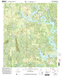
2000 Map of Black Pond
USGS Topo · Published 2003About this map
William B Bankhead National Forest defines the rugged geography of Winston County, Alabama, where the deep waters of Lewis Smith Lake fill the branching valleys of the Sipsey Fork and Clear Creek. This millennium-era record details a landscape of managed timberlands and utility, featuring several strip mines and associated tailings ponds concentrated west of the lake's fingers. Historic rural life is preserved through numerous family and community landmarks, including the Old Oak Grove Cem, Bethlehem Cem, and Wilson Cem. Small settlements like Curtis Crossroads and Black Pond persist near high points such as the Black Pond Lookout, while the lake's edge has transitioned into a recreational hub marked by the Corinth Recreation Area and Arley Landing. The intricate shoreline and network of forest roads reflect the area's dual character as both an industrial resource and a preserved wilderness.
Find a feature on this map
51 named features on this map. Tap any name to fly to it.
Don’t see what you’re looking for? This feature index may not catch every label — zoom into the map to look around manually.
Map Details
Editions of this 2000 Black Pond Map
This is the sole edition of this map. No revisions or reprints were ever made.
Other maps of this area

1893 · Jasper
USGS Topo · 1:125,000

1949 · Manchester
USGS Topo · 1:24,000

1949 · Nauvoo
USGS Topo · 1:24,000

1949 · Sunlight
USGS Topo · 1:24,000

1950 · Nauvoo
USGS Topo · 1:24,000

1950 · Manchester
USGS Topo · 1:24,000
1951 · Sunlight
USGS Topo · 1:24,000

1953 · Birmingham
USGS Topo · 1:250,000

1956 · Birmingham
USGS Topo · 1:250,000

1956 · Gadsden
USGS Topo · 1:250,000