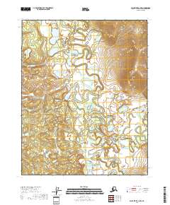
2018 Map of Black River A-3 NW
USGS Topo · Published 2018About this map
The Draanjik River meanders through this remote interior landscape, creating a complex network of oxbows and abandoned channels across the Yukon-Koyukuk region. In this hydrologically active environment, the Graveling Fork Black River and Coal Creek drain into a vast system of wetlands and small lakes. The most prominent water body on this sheet is Bear Mountain Lake, situated in the southern portion of the quadrangle near the headwaters of Owl Cr. The intricate topography of the river basins reveals a landscape defined by seasonal water flow and shifting alluvial patterns, typical of the subarctic wilderness before significant human infrastructure reached these reaches of the Alaskan interior.
Find a feature on this map
10 named features on this map. Tap any name to fly to it.
Don’t see what you’re looking for? This feature index may not catch every label — zoom into the map to look around manually.
Map Details
Editions of this 2018 Black River A-3 NW Map
This is the sole edition of this map. No revisions or reprints were ever made.
Other maps of this area

1951 · Black River
USGS Topo · 1:250,000

1956 · Black River A-4
USGS Topo · 1:63,360

1956 · Black River B-3
USGS Topo · 1:63,360

1956 · Black River A-3
USGS Topo · 1:63,360

1956 · Black River B-4
USGS Topo · 1:63,360

1956 · Black River
USGS Topo · 1:250,000

1964 · Black River
USGS Topo · 1:250,000
1984 · Black River A-4
USGS Topo · 1:63,360
2018 · Black River A-3 SE
USGS Topo · 1:25,000
2018 · Black River B-3 SW
USGS Topo · 1:25,000