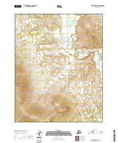
2018 Map of Black River A-3 SW
USGS Topo · Published 2018About this map
Draanjik River meanders through this remote portion of the Yukon-Koyukuk region, defining a landscape of intricate waterways and subtle elevation changes. The presence of Big Duck Lake in the northern reaches, combined with the winding course of the river, suggests a complex wetland environment characteristic of the Alaskan interior. In the southwestern quadrant, the terrain rises significantly toward the peak of Fanny Mtn, providing a distinct topographical contrast to the low-lying river basin. The drainage patterns of Mountain Cr further illustrate the watershed's connectivity, reflecting the untouched hydrology of the area as documented in this 2018 survey. This map serves as a clear record of the area's natural state, focusing on the relationship between its water bodies and prominent landforms.
Find a feature on this map
8 named features on this map. Tap any name to fly to it.
Don’t see what you’re looking for? This feature index may not catch every label — zoom into the map to look around manually.
Map Details
Editions of this 2018 Black River A-3 SW Map
This is the sole edition of this map. No revisions or reprints were ever made.
Other maps of this area

1951 · Charley River
USGS Topo · 1:250,000

1951 · Black River
USGS Topo · 1:250,000

1956 · Black River A-4
USGS Topo · 1:63,360

1956 · Black River A-3
USGS Topo · 1:63,360
1956 · Charley River D-4
USGS Topo · 1:63,360

1956 · Charley River D-3
USGS Topo · 1:63,360

1956 · Black River
USGS Topo · 1:250,000

1956 · Charley River
USGS Topo · 1:250,000

1964 · Black River
USGS Topo · 1:250,000
1984 · Black River A-4
USGS Topo · 1:63,360