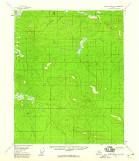
1956 Map of Charley River D-4
USGS Topo · Published 1960About this map
Bear Mountain dominates the northern reaches of this remote Alaskan interior landscape, situated just south of the Arctic Circle during the mid-1950s. The terrain is defined by dramatic elevation changes, with the headwaters of Bear Creek winding through the high country. As part of a 1956 field annotation effort, the map captures a vast, roadless wilderness long before modern infrastructure reached this portion of the Yukon-Koyukuk region. The absence of settlements or named structures on this sheet underscores the isolation of the Charley River drainage during the post-war era, serving as a primary record of the topographic character of the land as it existed prior to later development or conservation designations.
Find a feature on this map
8 named features on this map. Tap any name to fly to it.
Don’t see what you’re looking for? This feature index may not catch every label — zoom into the map to look around manually.
Map Details
Editions of this 1956 Charley River D-4 Map
2 editions found
Other maps of this area

1951 · Charley River
USGS Topo · 1:250,000

1951 · Black River
USGS Topo · 1:250,000

1956 · Black River A-4
USGS Topo · 1:63,360

1956 · Black River A-3
USGS Topo · 1:63,360
1956 · Black River A-5
USGS Topo · 1:63,360
1956 · Charley River D-5
USGS Topo · 1:63,360

1956 · Charley River C-5
USGS Topo · 1:63,360

1956 · Charley River D-3
USGS Topo · 1:63,360

1956 · Black River
USGS Topo · 1:250,000

1956 · Charley River C-4
USGS Topo · 1:63,360