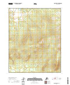
2018 Map of Black River A-4 SE
USGS Topo · Published 2018About this map
Bear Mtn dominates the eastern-central landscape of this interior Alaskan wilderness, serving as the topographical anchor for the surrounding high-altitude terrain. The map details the headwaters and drainage patterns of the region, specifically tracking Bear Mountain Cr as it flows from the southwestern slopes. The absence of roads or permanent structures reflects the extreme isolation of the Yukon-Koyukuk Census Area, where the landscape is defined primarily by steep elevation changes and natural watercourses. Surveyed with 40-foot contour intervals, this sheet provides a detailed look at the physical geography between the T14N and T15N township lines, capturing a pristine environment before any modern development or infrastructure reached this part of the Black River region.
Find a feature on this map
6 named features on this map. Tap any name to fly to it.
Don’t see what you’re looking for? This feature index may not catch every label — zoom into the map to look around manually.
Map Details
Editions of this 2018 Black River A-4 SE Map
This is the sole edition of this map. No revisions or reprints were ever made.
Other maps of this area

1951 · Charley River
USGS Topo · 1:250,000

1951 · Black River
USGS Topo · 1:250,000

1956 · Black River A-4
USGS Topo · 1:63,360

1956 · Black River A-3
USGS Topo · 1:63,360
1956 · Charley River D-4
USGS Topo · 1:63,360

1956 · Charley River D-3
USGS Topo · 1:63,360

1956 · Black River
USGS Topo · 1:250,000

1956 · Charley River
USGS Topo · 1:250,000

1964 · Black River
USGS Topo · 1:250,000
1984 · Black River A-4
USGS Topo · 1:63,360