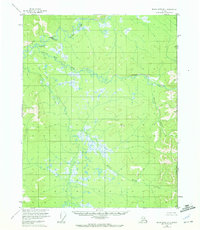
1956 Map of Black River B-1
USGS Topo · Published 1972About this map
The United States Canada international border marks the eastern edge of this 1950s interior Alaskan landscape, where the Alaska Yukon boundary cuts through a complex network of subarctic waterways. The drainage system is dominated by the Black River and its major tributary, the Salmon Fork, which wind through a terrain characterized by numerous unnamed lakes and swampy lowlands. Human presence is exceptionally sparse in this region, anchored primarily by the John Roberts Cabin situated along the river fork.
Find a feature on this map
9 named features on this map. Tap any name to fly to it.
Don’t see what you’re looking for? This feature index may not catch every label — zoom into the map to look around manually.
Map Details
Editions of this 1956 Black River B-1 Map
2 editions found
Other maps of this area

1951 · Black River
USGS Topo · 1:250,000
1956 · Black River A-1
USGS Topo · 1:63,360

1956 · Black River A-2
USGS Topo · 1:63,360

1956 · Black River B-2
USGS Topo · 1:63,360

1956 · Black River B-1
USGS Topo · 1:63,360

1956 · Black River C-2
USGS Topo · 1:63,360
1956 · Black River C-1
USGS Topo · 1:63,360

1956 · Black River
USGS Topo · 1:250,000

1964 · Black River
USGS Topo · 1:250,000
2018 · Black River B-1 NW
USGS Topo · 1:25,000