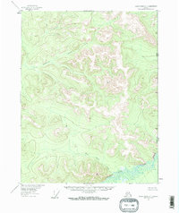
1956 Map of Black River C-1
USGS Topo · Published 1959About this map
The Alaska Yukon border defines the eastern edge of this 1950s survey, marking the international line where the United States Canada boundary cuts through the interior wilderness. The landscape is dominated by the complex drainage systems of the Salmon Fork Black River, which winds across the southern reaches of the sheet. Survey control points like VABM 3208 White and VABM 2849 Circle indicate the primary high points used by the U.S. Geological Survey and the International Boundary Commission to triangulate this remote terrain. Tributaries such as Tetthajik Creek and Rice Gulch carve through the uplands, illustrating the hydrologic patterns of the region before any modern infrastructure reached these latitudes. This map represents a purely topographical study of the Alaskan interior, focused on precise boundary demarcation and watercourse mapping.
Find a feature on this map
7 named features on this map. Tap any name to fly to it.
Don’t see what you’re looking for? This feature index may not catch every label — zoom into the map to look around manually.
Map Details
Editions of this 1956 Black River C-1 Map
2 editions found
Other maps of this area

1951 · Black River
USGS Topo · 1:250,000

1956 · Black River B-2
USGS Topo · 1:63,360

1956 · Black River B-1
USGS Topo · 1:63,360

1956 · Black River C-2
USGS Topo · 1:63,360

1956 · Black River D-2
USGS Topo · 1:63,360
1956 · Black River C-1
USGS Topo · 1:63,360
1956 · Black River D-1
USGS Topo · 1:63,360

1956 · Black River
USGS Topo · 1:250,000

1964 · Black River
USGS Topo · 1:250,000
2018 · Black River B-1 NW
USGS Topo · 1:25,000