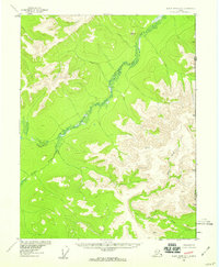
1956 Map of Black River D-1
USGS Topo · Published 1959About this map
The Salmon Trout River meanders through a valley in the northern reaches of the Yukon-Koyukuk region, its course flanked by elevation markers that define the complex terrain of the late 1950s. This survey records a wilderness largely untouched by permanent settlement, where the landscape is defined by the Alaska Yukon and United States Canada international boundaries. Significant vertical control points like Vabm 3651 Storm and Vabm 3420 Fort serve as the primary landmarks in a region without roads or trails.
Find a feature on this map
7 named features on this map. Tap any name to fly to it.
Don’t see what you’re looking for? This feature index may not catch every label — zoom into the map to look around manually.
Map Details
Editions of this 1956 Black River D-1 Map
2 editions found
Other maps of this area

1951 · Black River
USGS Topo · 1:250,000

1951 · Coleen
USGS Topo · 1:250,000

1956 · Coleen
USGS Topo · 1:250,000

1956 · Coleen A-1
USGS Topo · 1:63,360

1956 · Black River C-2
USGS Topo · 1:63,360

1956 · Black River D-2
USGS Topo · 1:63,360
1956 · Black River C-1
USGS Topo · 1:63,360

1956 · Coleen A-2
USGS Topo · 1:63,360

1956 · Black River
USGS Topo · 1:250,000

1964 · Black River
USGS Topo · 1:250,000