
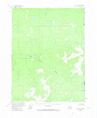
1956 Map of Coleen A-1
USGS Topo · Published 1959About this map
The Salmon Trout River flows through this high-latitude terrain, winding toward the international boundary where the Alaska Yukon border meets. This mid-century survey by the Geological Survey and International Boundary Commission documents a landscape defined by sharp elevation shifts and unnamed peaks, punctuated by survey control points like Vabm 1930 and the triangulation station at Smith. In the northern section, the Campbell River cuts through the topography, which transitions from river valleys to high ridges such as Arch 2. The absence of roads or established settlements emphasizes the remote nature of this portion of the United States Canada border, serving as a snapshot of the region before modern digital mapping, based on aerial photography taken during the 1950s.
Find a feature on this map
7 named features on this map. Tap any name to fly to it.
Don’t see what you’re looking for? This feature index may not catch every label — zoom into the map to look around manually.
Map Details
Editions of this 1956 Coleen A-1 Map
2 editions found
Other maps of this area

1951 · Black River
USGS Topo · 1:250,000

1951 · Coleen
USGS Topo · 1:250,000

1956 · Coleen
USGS Topo · 1:250,000

1956 · Coleen B-2
USGS Topo · 1:63,360
1956 · Coleen B-1
USGS Topo · 1:63,360

1956 · Black River D-2
USGS Topo · 1:63,360
1956 · Black River D-1
USGS Topo · 1:63,360

1956 · Coleen A-2
USGS Topo · 1:63,360

1956 · Black River
USGS Topo · 1:250,000

1964 · Black River
USGS Topo · 1:250,000