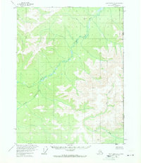
1956 Map of Black River D-1
USGS Topo · Published 1971About this map
The Salmon Trout River meanders across this interior wilderness along the international boundary, a landscape defined by sharp elevation shifts and remote survey points. Mapped via aerial photography in the mid-1950s, the terrain shows no established roads or trails, reflecting a truly untouched portion of the northeastern Alaskan borderlands. Vertical control stations like VABM 3651 Storm and VABM 2144 Lone stand as isolated landmarks for bush pilots and surveyors navigating the high ridges above the river valley. The eastern edge of the sheet follows the United States Canada border, marking the transition from Alaska into the Yukon. This area is dominated by the drainage system of Fort Creek and the high point at VABM 3420 Fort, offering a precise record of the topographical relief in a region where few human footprints are recorded.
Find a feature on this map
7 named features on this map. Tap any name to fly to it.
Don’t see what you’re looking for? This feature index may not catch every label — zoom into the map to look around manually.
Map Details
Editions of this 1956 Black River D-1 Map
2 editions found
Other maps of this area

1951 · Black River
USGS Topo · 1:250,000

1951 · Coleen
USGS Topo · 1:250,000

1956 · Coleen
USGS Topo · 1:250,000

1956 · Coleen A-1
USGS Topo · 1:63,360

1956 · Black River C-2
USGS Topo · 1:63,360

1956 · Black River D-2
USGS Topo · 1:63,360
1956 · Black River C-1
USGS Topo · 1:63,360
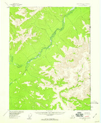
1956 · Black River D-1
USGS Topo · 1:63,360

1956 · Coleen A-2
USGS Topo · 1:63,360

1956 · Black River
USGS Topo · 1:250,000