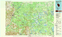
1985 Map of Black River Falls
USGS Topo · Published 1989About this map
Black River State Forest dominates the central landscape of this mid-1980s regional survey, where the Black River carves a path through heavy woodlands and scattered wetlands. The map illustrates a transitional geography between the central plains and the western coulees, characterized by dramatic sandstone features like Silver Mound and Bear Bluff. To the east, the vast marshes and Cranberry Bogs of the Necedah National Wildlife Refuge contrast with the rugged terrain of the Fort McCoy Military Reservation in the southwest.
Find a feature on this map
178 named features on this map. Tap any name to fly to it.
Don’t see what you’re looking for? This feature index may not catch every label — zoom into the map to look around manually.
Map Details
Editions of this 1985 Black River Falls Map
2 editions found
Other maps of this area

1909 · Sparta
USGS Topo · 1:62,500

1916 · Tomah
USGS Topo · 1:62,500

1919 · Kendall
USGS Topo · 1:62,500

1921 · Mauston
USGS Topo · 1:62,500

1921 · Kendall
USGS Topo · 1:62,500

1924 · Black River Falls
USGS Topo · 1:62,500

1926 · Black River Falls
USGS Topo · 1:62,500

1926 · North Bend
USGS Topo · 1:62,500

1927 · Blair
USGS Topo · 1:62,500

1927 · La Crosse
USGS Topo · 1:62,500