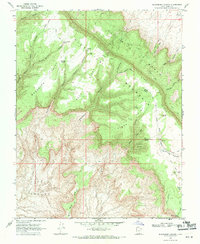
1968 Map of Blackburn Canyon
USGS Topo · Published 1971About this map
Fiftymile Mountain dominates this portion of the Straight Cliffs, a dramatic escarpment that defines the high plateau geography of Southern Utah. This 1968 field survey reveals a landscape of deep erosional features like Monday Canyon and Buck Canyon, accessed only by a network of primitive routes designated as either Pack Trail or Jeep Trail. Such a network suggests a mid-century reliance on traditional livestock grazing and mineral exploration in a region far removed from established towns.
Find a feature on this map
39 named features on this map. Tap any name to fly to it.
Don’t see what you’re looking for? This feature index may not catch every label — zoom into the map to look around manually.
Map Details
Editions of this 1968 Blackburn Canyon Map
2 editions found
Other maps of this area

1886 · Escalante
USGS Topo · 1:250,000

1922 · Warm Creek
USGS Topo · 1:63,360

1922 · Rees Canyon
USGS Topo · 1:63,360

1953 · Cummings Mesa
USGS Topo · 1:62,500

1953 · Gunsight Butte
USGS Topo · 1:62,500

1956 · Escalante
USGS Topo · 1:250,000

1960 · Escalante
USGS Topo · 1:250,000

1968 · East of The Navajo
USGS Topo · 1:24,000
1968 · Big Hollow Wash
USGS Topo · 1:24,000
1968 · Basin Canyon
USGS Topo · 1:24,000