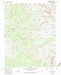
1982 Map of Blackcap Mtn
USGS Topo · Published 1983About this map
Le Conte Divide serves as a high-altitude spine through this high sierra terrain, separating the basins of the North Fork Kings River from the steep descent into Goddard Canyon. The area is characterized by a high density of alpine lakes and meadows, reflecting a landscape shaped by glacial activity rather than permanent settlement. Meadow Brook Cabin and a nearby campsite provide the only indications of human habitation, likely serving as seasonal outposts for forest management or high-country travelers within the Sierra National Forest.
Find a feature on this map
69 named features on this map. Tap any name to fly to it.
Don’t see what you’re looking for? This feature index may not catch every label — zoom into the map to look around manually.
Map Details
Editions of this 1982 Blackcap Mtn Map
3 editions found
Other maps of this area

1903 · Tehipite
USGS Topo · 1:125,000

1905 · Tehipite
USGS Topo · 1:125,000

1912 · Mt. Goddard
USGS Topo · 1:125,000

1947 · Mariposa
USGS Topo · 1:250,000

1948 · Fresno
USGS Topo · 1:250,000

1948 · Mariposa
USGS Topo · 1:250,000

1948 · Mt. Goddard
USGS Topo · 1:62,500

1951 · Mt. Goddard
USGS Topo · 1:62,500

1952 · Mt. Goddard
USGS Topo · 1:62,500

1952 · Tehipite Dome
USGS Topo · 1:62,500