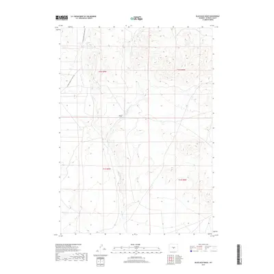
2017 Map of Blackjack Ranch
USGS Topo · Published 2017About this map
Blackjack Ranch serves as the primary landmark in this area of Natrona County, where the high desert landscape is defined by the drainage of Sage Hen Cr. The map details a network of drainage systems, including the E Fork Sage Hen Cr, which carve through the terrain as it rises toward the surrounding divides. Historical transportation is represented by the Waltman Sweetwater Freight Rd, a route that points to the era of overland freighting and early commerce in central Wyoming. This 2017 survey by the U.S. Geological Survey captures the modern state of these remote ranchlands while preserving the original paths of early industrial roads and established water sources.
Find a feature on this map
8 named features on this map. Tap any name to fly to it.
Don’t see what you’re looking for? This feature index may not catch every label — zoom into the map to look around manually.
Map Details
Editions of this 2017 Blackjack Ranch Map
This is the sole edition of this map. No revisions or reprints were ever made.
Other maps of this area

1951 · Lone Mountain
USGS Topo · 1:24,000

1951 · Lankin Dome
USGS Topo · 1:24,000

1952 · Ervay Basin SW
USGS Topo · 1:24,000

1952 · Gas Hills
USGS Topo · 1:24,000

1952 · Mc Intosh Meadows
USGS Topo · 1:24,000

1955 · Casper
USGS Topo · 1:250,000

1958 · Casper
USGS Topo · 1:250,000
1958 · Gas Hills
USGS Topo · 1:24,000

1959 · Miller Spring
USGS Topo · 1:24,000

1959 · Blackjack Ranch
USGS Topo · 1:24,000