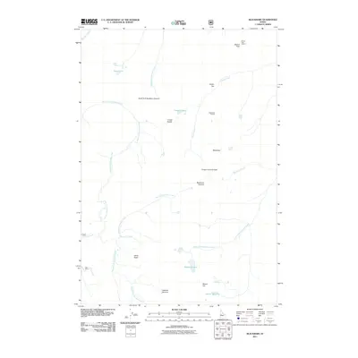
2011 Map of Blackmare
USGS Topo · Published 2011About this map
Miners Peak Lookout and Blackmare Lookout watch over a high-altitude landscape defined by the complex drainages of the Payette National Forest region. This 2011 survey illustrates the intricate hydrography of the Salmon River Mountains, where the waters of Kennally Creek and its many forks—the North Fork, East Fork, and South Fork—converge to shape the central terrain. Higher elevations are marked by alpine features such as Blackmare Lake, Petes Lake, and Square Top Lake, often situated near prominent points like Blackmare Summit or the distinctive White Rocks formation. The absence of developed roads or towns highlights the primitive character of this Idaho backcountry, where geography is recorded through peaks like Miners Peak and topographic crossings such as Cougar Saddle.
Find a feature on this map
25 named features on this map. Tap any name to fly to it.
Don’t see what you’re looking for? This feature index may not catch every label — zoom into the map to look around manually.
Map Details
Editions of this 2011 Blackmare Map
This is the sole edition of this map. No revisions or reprints were ever made.
Other maps of this area

1954 · Gold Fork
USGS Topo · 1:62,500

1954 · Warm Lake
USGS Topo · 1:62,500

1957 · Challis
USGS Topo · 1:250,000

1960 · Challis
USGS Topo · 1:250,000

1963 · Challis
USGS Topo · 1:250,000

1973 · Blackmare
USGS Topo · 1:24,000

1973 · White Rock Peak
USGS Topo · 1:24,000

1973 · Fitsum Peak
USGS Topo · 1:24,000
1973 · Paddy Flat
USGS Topo · 1:24,000
1973 · Teapot Mtn
USGS Topo · 1:24,000