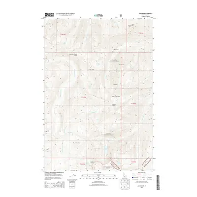
2013 Map of Blackmare
USGS Topo · Published 2013About this map
Blackmare Lookout and Miners Peak Lookout crown the high ridges of this central Idaho landscape, serving as critical observation points overlooking the vast drainages of the Payette National Forest and Boise National Forest. The 2013 topography reveals a network of high-altitude basins where glacial activity left behind numerous water bodies, including Blackmare Lake, the twin Cougar Lakes, and the isolated Dismal Lake.
Find a feature on this map
38 named features on this map. Tap any name to fly to it.
Don’t see what you’re looking for? This feature index may not catch every label — zoom into the map to look around manually.
Map Details
Editions of this 2013 Blackmare Map
This is the sole edition of this map. No revisions or reprints were ever made.
Other maps of this area

1954 · Gold Fork
USGS Topo · 1:62,500

1954 · Warm Lake
USGS Topo · 1:62,500

1957 · Challis
USGS Topo · 1:250,000

1960 · Challis
USGS Topo · 1:250,000

1963 · Challis
USGS Topo · 1:250,000

1973 · Blackmare
USGS Topo · 1:24,000

1973 · White Rock Peak
USGS Topo · 1:24,000

1973 · Fitsum Peak
USGS Topo · 1:24,000
1973 · Paddy Flat
USGS Topo · 1:24,000
1973 · Teapot Mtn
USGS Topo · 1:24,000