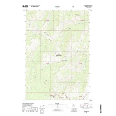
2020 Map of Blackmare
USGS Topo · Published 2020About this map
Payette National Forest and the Boise National Forest meet in this high-elevation Idaho landscape, where the headwaters of numerous forks and creeks carve through the terrain. The map identifies the remote Hot Spring located along the E Fork Kennally Creek, a notable landmark for those tracing old trails or geothermal features in the Salmon River Mountains. High peaks and ridges dominate the topography, with Miners Peak standing at the northern edge and Square Top rising in the south near Square Top Lake.
Find a feature on this map
41 named features on this map. Tap any name to fly to it.
Don’t see what you’re looking for? This feature index may not catch every label — zoom into the map to look around manually.
Map Details
Editions of this 2020 Blackmare Map
This is the sole edition of this map. No revisions or reprints were ever made.
Other maps of this area

1954 · Gold Fork
USGS Topo · 1:62,500

1954 · Warm Lake
USGS Topo · 1:62,500

1957 · Challis
USGS Topo · 1:250,000

1960 · Challis
USGS Topo · 1:250,000

1963 · Challis
USGS Topo · 1:250,000

1973 · Blackmare
USGS Topo · 1:24,000

1973 · White Rock Peak
USGS Topo · 1:24,000

1973 · Fitsum Peak
USGS Topo · 1:24,000
1973 · Paddy Flat
USGS Topo · 1:24,000
1973 · Teapot Mtn
USGS Topo · 1:24,000