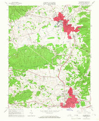
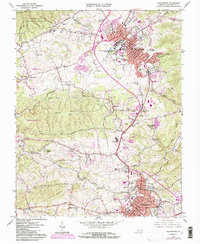
1965 Map of Blacksburg
USGS Topo · Published 1966About this map
Virginia Polytechnic Institute serves as the focal point of this mid-1960s landscape, featuring prominent campus landmarks like the Coliseum and Lane Stadium. The map documents the spatial relationship between the growing urban centers of Blacksburg and Christiansburg, connected by the Norfolk and Western railway and a network of rural roads leading to older settlements. Historic crossroads like Prices Fork and Merrimac appear alongside industrial and recreational sites, including several quarries and the Swanee Hollow Country Club.
Find a feature on this map
67 named features on this map. Tap any name to fly to it.
Don’t see what you’re looking for? This feature index may not catch every label — zoom into the map to look around manually.
Map Details
Editions of this 1965 Blacksburg Map
5 editions found
Other maps of this area

1890 · Dublin
USGS Topo · 1:125,000

1890 · Christiansburg
USGS Topo · 1:125,000

1891 · Dublin
USGS Topo · 1:125,000

1923 · Pearisburg
USGS Topo · 1:62,500

1923 · Waiteville
USGS Topo · 1:62,500

1931 · Waiteville
USGS Topo · 1:48,000

1932 · Pearisburg
USGS Topo · 1:48,000

1932 · Blacksburg
USGS Topo · 1:48,000

1937 · Pearisburg
USGS Topo · 1:62,500

1937 · Blacksburg
USGS Topo · 1:62,500