
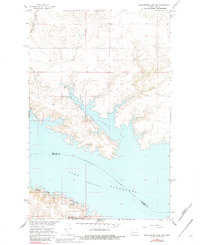
1967 Map of Blackwater Lake SW
USGS Topo · Published 1969About this map
Lake Sakakawea dominates the landscape of this McLean County survey, reflecting the transformed Missouri River valley following the construction of the Garrison Dam. The reservoir's reach into Nishu Bay and the surrounding inlets created a complex shoreline where the Missouri River once flowed more freely between the McLean and Mercer county lines. Land management and public access points like the Nishu Public Use Area and the Beaver Creek State Game Management Area show the shift toward conservation and recreation in the mid-1960s. High ground features like Buffalo Rock Coulee and Sixmile Creek drain into the rising waters, while the Beaver Creek Cem stands as a quiet remnant of the area's rural upland history, situated just north of the Beaver Creek arm of the lake.
Find a feature on this map
11 named features on this map. Tap any name to fly to it.
Don’t see what you’re looking for? This feature index may not catch every label — zoom into the map to look around manually.
Map Details
Editions of this 1967 Blackwater Lake SW Map
2 editions found
Other maps of this area

1953 · Watford City
USGS Topo · 1:250,000

1954 · McClusky
USGS Topo · 1:250,000

1956 · Blackwater Lake NW
USGS Topo · 1:24,000

1956 · Blackwater Lake
USGS Topo · 1:24,000

1957 · Watford City
USGS Topo · 1:250,000

1958 · McClusky
USGS Topo · 1:250,000

1967 · Watford City
USGS Topo · 1:250,000

1967 · Blackwater Lake SE
USGS Topo · 1:24,000

1967 · Raub SE
USGS Topo · 1:24,000

1967 · Raub
USGS Topo · 1:24,000