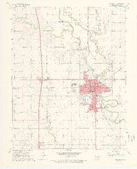
1968 Map of Blackwell
USGS Topo · Published 1970About this map
The Chikaskia River winds across this northern Oklahoma landscape, defining the northern and eastern borders of Blackwell. By the late 1960s, the town had developed into a significant regional hub, anchored by its proximity to the Blackwell Oil and Gas Field and the Hubbard Oil Field. The community's infrastructure is well-defined, featuring schools such as Northside Sch and Parkside Sch, alongside the IOOF Cemetery.
Find a feature on this map
50 named features on this map. Tap any name to fly to it.
Don’t see what you’re looking for? This feature index may not catch every label — zoom into the map to look around manually.
Map Details
Editions of this 1968 Blackwell Map
2 editions found
Other maps of this area

1955 · Enid
USGS Topo · 1:250,000

1958 · Enid
USGS Topo · 1:250,000

1967 · Braman
USGS Topo · 1:24,000

1968 · Ponca City NW
USGS Topo · 1:24,000

1968 · Eddy
USGS Topo · 1:24,000

1968 · Blackwell NW
USGS Topo · 1:24,000

1968 · Nardin
USGS Topo · 1:24,000

1968 · Tonkawa
USGS Topo · 1:24,000

1968 · Blackwell
USGS Topo · 1:24,000
1968 · Newkirk SW
USGS Topo · 1:24,000