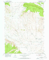
1950 Map of Blair Basin
USGS Topo · Published 1972About this map
Uinta Mountains ranching life and high-desert terrain define this mid-century survey of northeastern Utah. The map documents a dispersed network of family-owned homesteads and grazing operations, including the Carl Searle Ranch and McKeachnie Ranch, situated between the elevations of the Diamond Mountain Plateau and the floor of Diamond Valley. The landscape is etched by seasonal water sources like Diamond Gulch and Pot Creek, which were vital for sustaining livestock in this arid environment. Bordering the Ashley Nat Forest, the region shows a clear transition from protected timberland to the open range of Blair Basin. For genealogists and local historians, the specific placement of the Willis Ranch, Goodrich Ranch, and various springs provides a precise record of land use before modern consolidation and development altered the character of these Uintah County properties.
Find a feature on this map
19 named features on this map. Tap any name to fly to it.
Don’t see what you’re looking for? This feature index may not catch every label — zoom into the map to look around manually.
Map Details
Editions of this 1950 Blair Basin Map
2 editions found
Other maps of this area

1885 · Ashley
USGS Topo · 1:250,000

1950 · Burnt Cabin Gorge
USGS Topo · 1:24,000

1950 · Blair Basin
USGS Topo · 1:24,000

1952 · Warren Draw
USGS Topo · 1:24,000

1954 · Vernal
USGS Topo · 1:250,000

1955 · Island Park
USGS Topo · 1:24,000

1958 · Vernal
USGS Topo · 1:250,000

1960 · Vernal
USGS Topo · 1:250,000
1965 · Donkey Flat
USGS Topo · 1:24,000
1966 · Jensen Ridge
USGS Topo · 1:24,000