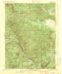
1943 Map of Blairsden
USGS Topo · Published 1943About this map
The Western Pacific Railroad snakes along the Middle Fork Feather River and through Long Valley in this 1943 edition, showing the industrial and topographical heart of Plumas County. High in the mountains, the Walker Mine and the settlement of Walkermine represent the region's copper mining legacy, connected by a specialized Tramway to transport ore. The map details a landscape transition from high peaks like Mt Ingalls and Penman Pk down to the settled resort and timber areas of Blairsden and Graeagle.
Find a feature on this map
70 named features on this map. Tap any name to fly to it.
Don’t see what you’re looking for? This feature index may not catch every label — zoom into the map to look around manually.
Map Details
Editions of this 1943 Blairsden Map
3 editions found

Other maps of this area

1886 · Honey Lake
USGS Topo · 1:250,000

1890 · Sierraville
USGS Topo · 1:125,000

1891 · Downieville
USGS Topo · 1:125,000

1891 · Honey Lake
USGS Topo · 1:250,000

1892 · Sierraville
USGS Topo · 1:125,000

1893 · Honey Lake
USGS Topo · 1:250,000

1893 · Downieville
USGS Topo · 1:125,000

1894 · Sierraville
USGS Topo · 1:125,000

1895 · Downieville
USGS Topo · 1:125,000

1896 · Downieville
USGS Topo · 1:125,000