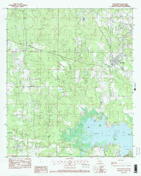
1982 Map of Blanchard
USGS Topo · Published 1982About this map
The northern reaches of Cross Lake dominate the southern portion of this landscape, where the Shreveport Corp Limits trace the complex shoreline around Pine Island and the Twin Islands. The topography is defined by an intricate network of waterways draining toward the lake, including Choctaw Bayou and Shettleworth Bayou. Small residential clusters and rural outposts such as Blanchard and Longwood indicate the early 1980s suburban expansion and rural settlement patterns of Caddo Parish.
Find a feature on this map
21 named features on this map. Tap any name to fly to it.
Don’t see what you’re looking for? This feature index may not catch every label — zoom into the map to look around manually.
Map Details
Editions of this 1982 Blanchard Map
2 editions found
Other maps of this area

1932 · Shreveport SE
USGS Topo · 1:31,680

1932 · Shreveport NE
USGS Topo · 1:31,680

1943 · Waskom
USGS Topo · 1:62,500

1944 · Caddo Lake
USGS Topo · 1:62,500

1945 · Waskom
USGS Topo · 1:62,500

1945 · Greenwood
USGS Topo · 1:62,500

1946 · Caddo Lake
USGS Topo · 1:62,500

1948 · Mooringsport
USGS Topo · 1:62,500

1955 · Shreveport
USGS Topo · 1:250,000
1955 · North Shreveport
USGS Topo · 1:24,000