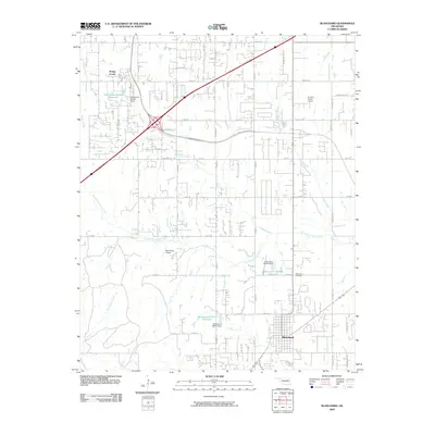
2009 Map of Blanchard
USGS Topo · Published 2009About this map
Blanchard sits at the heart of this central Oklahoma landscape, where the town's expansion meets the rural character of McClain County. The area is defined by a dendritic network of streams including North Fork Walnut Creek and East Bitter Creek, which feed into several engineered water bodies such as Oknoname 051013 Reservoir. The map illustrates the region's connectivity via the H E Bailey Turnpike Norman Spr and a dense grid of rural roads like 7 Mile Line.
Find a feature on this map
57 named features on this map. Tap any name to fly to it.
Don’t see what you’re looking for? This feature index may not catch every label — zoom into the map to look around manually.
Map Details
Editions of this 2009 Blanchard Map
This is the sole edition of this map. No revisions or reprints were ever made.
Other maps of this area

1893 · Oklahoma City
USGS Topo · 1:62,500

1893 · Minco
USGS Topo · 1:62,500

1904 · Chickasha
USGS Topo · 1:125,000

1954 · Oklahoma City
USGS Topo · 1:250,000

1956 · Oklahoma City
USGS Topo · 1:62,500

1956 · Oklahoma City SE
USGS Topo · 1:24,000

1957 · Oklahoma City
USGS Topo · 1:250,000

1963 · Oklahoma City
USGS Topo · 1:250,000
1965 · Newcastle
USGS Topo · 1:24,000
1965 · Cole
USGS Topo · 1:24,000