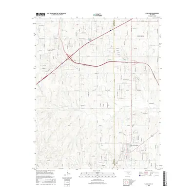
2016 Map of Blanchard
USGS Topo · Published 2016About this map
Blanchard sits at the southern end of this survey, where the local road network converges near the Blanchard Cem. This region of Central Oklahoma is defined by a dendritic drainage system including the N Fork Walnut Cr and Stinson Cr, which shape the land between the growing communities of Newcastle and Bridge Creek. The map documents a period of significant suburban expansion and infrastructure development, particularly evident in the dense residential street naming and the prominent highway corridors that connect these settlements. The boundary between Grady Co and McClain Co runs vertically through the center of the sheet, dividing the landscape between western hills and eastern plains. Local life is reflected in family-named routes and rural thoroughfares like Bridge Creek Rd and Walking Horse Ln, marking the transition from agricultural tracts to a more densely populated commuter corridor.
Find a feature on this map
158 named features on this map. Tap any name to fly to it.
Don’t see what you’re looking for? This feature index may not catch every label — zoom into the map to look around manually.
Map Details
Editions of this 2016 Blanchard Map
This is the sole edition of this map. No revisions or reprints were ever made.
Other maps of this area

1893 · Oklahoma City
USGS Topo · 1:62,500

1893 · Minco
USGS Topo · 1:62,500

1904 · Chickasha
USGS Topo · 1:125,000

1954 · Oklahoma City
USGS Topo · 1:250,000

1956 · Oklahoma City
USGS Topo · 1:62,500

1956 · Oklahoma City SE
USGS Topo · 1:24,000

1957 · Oklahoma City
USGS Topo · 1:250,000

1963 · Oklahoma City
USGS Topo · 1:250,000
1965 · Newcastle
USGS Topo · 1:24,000
1965 · Cole
USGS Topo · 1:24,000