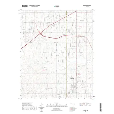
2018 Map of Blanchard
USGS Topo · Published 2018About this map
Blanchard and Newcastle anchor this suburbanizing landscape on the border of Grady and McClain counties. The region is defined by its transition from traditional Oklahoma prairie to a complex network of residential subdivisions and rural homesteads, all intersected by a dense grid of county roads and section lines. Notable water features such as Bridge Creek and North Fork Walnut Creek carve through the terrain, accompanied by several unnamed reservoirs like 087010 Reservoir and 051013 Reservoir. Local history is anchored at the Blanchard Cem, while the modern aviation footprint is represented by Warbonnet Airport to the west. The map shows the significant sprawl of Bridge Creek and the emerging neighborhoods along South Rockwell Avenue, illustrating the area's growth at the intersection of local township roads and major thoroughfares.
Find a feature on this map
162 named features on this map. Tap any name to fly to it.
Don’t see what you’re looking for? This feature index may not catch every label — zoom into the map to look around manually.
Map Details
Editions of this 2018 Blanchard Map
This is the sole edition of this map. No revisions or reprints were ever made.
Other maps of this area

1893 · Oklahoma City
USGS Topo · 1:62,500

1893 · Minco
USGS Topo · 1:62,500

1904 · Chickasha
USGS Topo · 1:125,000

1954 · Oklahoma City
USGS Topo · 1:250,000

1956 · Oklahoma City
USGS Topo · 1:62,500

1956 · Oklahoma City SE
USGS Topo · 1:24,000

1957 · Oklahoma City
USGS Topo · 1:250,000

1963 · Oklahoma City
USGS Topo · 1:250,000
1965 · Newcastle
USGS Topo · 1:24,000
1965 · Cole
USGS Topo · 1:24,000