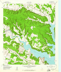
1958 Map of Bland
USGS Topo · Published 1961About this map
Fort Hood Military Reservation dominates the landscape of Bell and Coryell Counties in the late 1950s, showing a massive military landscape characterized by extensive reservation boundaries and rugged topography. The expansive Belton Reservoir fills the eastern portion of the sheet, its waters reaching into the valleys near Bland. This era of development highlights the intersection of federal defense land and civilian recreation, with the Fort Hood Recreation Area situated along the reservoir's banks. Local history is anchored by settlements like Sparta and Union Hill, alongside family landmarks such as Sparta Mountain and Bland Mountain. The map details a transition in the land, where traditional community life—represented by the County Line Community Ch and various creeks like Owl Creek—exists alongside modern infrastructure like a pipeline and aqueduct serving the growing regional needs.
Find a feature on this map
24 named features on this map. Tap any name to fly to it.
Don’t see what you’re looking for? This feature index may not catch every label — zoom into the map to look around manually.
Map Details
Editions of this 1958 Bland Map
Other maps of this area

1892 · Temple
USGS Topo · 1:125,000

1894 · Gatesville
USGS Topo · 1:125,000

1924 · Gatesville 4-d
USGS Topo · 1:48,000

1924 · Gatesville 4-a
USGS Topo · 1:48,000

1924 · Temple 2-C
USGS Topo · 1:48,000

1924 · Temple 3-C
USGS Topo · 1:48,000

1924 · Temple 3-B
USGS Topo · 1:48,000

1930 · Killeen
USGS Topo · 1:62,500

1931 · Mc Gregor
USGS Topo · 1:62,500

1931 · Belton
USGS Topo · 1:62,500