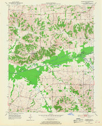
1951 Map of Blandville
USGS Topo · Published 1968About this map
The county line between Ballard and Carlisle Counties bisects this mid-century portrait of western Kentucky's creek-carved bottomlands. Small agricultural communities such as Blandville and Cunningham serve as focal points for a landscape defined by an intricate network of waterways, including the winding Mayfield Creek and its many tributaries like Wilson Creek and Hurricane Creek. The presence of St Arbor Slough and Magee Springs reflects the hydrologic complexity of this region just east of the Mississippi River floodplain.
Find a feature on this map
20 named features on this map. Tap any name to fly to it.
Don’t see what you’re looking for? This feature index may not catch every label — zoom into the map to look around manually.
Map Details
Editions of this 1951 Blandville Map
2 editions found
Other maps of this area

1928 · La Center
USGS Topo · 1:62,500

1931 · Cairo
USGS Topo · 1:62,500

1932 · La Center
USGS Topo · 1:62,500

1933 · Cairo
USGS Topo · 1:62,500

1939 · Wickliffe
USGS Topo · 1:62,500

1939 · Cairo
USGS Topo · 1:62,500

1949 · Paducah
USGS Topo · 1:250,000

1950 · Paducah
USGS Topo · 1:250,000

1951 · Blandville
USGS Topo · 1:24,000

1951 · Arlington
USGS Topo · 1:24,000