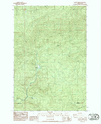
1986 Map of Blaney Creek
USGS Topo · Published 1986About this map
Grays River and its intricate drainage network define this timber-rich landscape in the mid-1980s, where the water flows through the steep elevations of Long Ridge. The map documents a rugged industrial and conservation environment, notably featuring the Grays River Salmon Pond along the main channel. Resource extraction is evident through the presence of a Quarry and Barrow Pit, situated among the numerous named tributaries like East Fork Grays River, South Fork Grays River, and Blaney Creek. The northern portion of the quadrangle shows the headwaters of the Willappa River, while the southern boundary marks the administrative divide between Pacific County and Wahkiakum County. This survey is particularly useful for understanding the hydrological patterns and logging infrastructure of the Pacific Northwest during this era.
Find a feature on this map
18 named features on this map. Tap any name to fly to it.
Don’t see what you’re looking for? This feature index may not catch every label — zoom into the map to look around manually.
Map Details
Editions of this 1986 Blaney Creek Map
This is the sole edition of this map. No revisions or reprints were ever made.
Other maps of this area

1940 · Brookfield
USGS Topo · 1:62,500

1941 · Walville
USGS Topo · 1:62,500

1941 · Skamokawa
USGS Topo · 1:62,500

1953 · Hoquiam
USGS Topo · 1:250,000

1953 · Skamokawa
USGS Topo · 1:62,500

1953 · Pe Ell
USGS Topo · 1:62,500

1955 · Grays River
USGS Topo · 1:62,500

1955 · Raymond
USGS Topo · 1:62,500

1957 · Hoquiam
USGS Topo · 1:250,000

1958 · Hoquiam
USGS Topo · 1:250,000