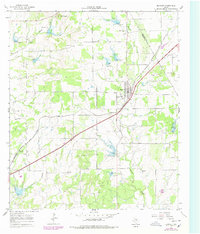
1966 Map of Blanket
USGS Topo · Published 1978About this map
The town of Blanket sits at the heart of this survey, where the Atchison Topeka and Santa Fe railroad cuts diagonally through the rural landscape. In the mid-1960s, this area of Brown County and neighboring Comanche County was characterized by its distributed network of small community landmarks and agricultural activity. The presence of numerous burial sites, including Eureka Cem, Moro Cem, and Antioch Cem, points to the long-settled family histories of the Texas plains.
Find a feature on this map
19 named features on this map. Tap any name to fly to it.
Don’t see what you’re looking for? This feature index may not catch every label — zoom into the map to look around manually.
Map Details
Editions of this 1966 Blanket Map
2 editions found
Other maps of this area

1889 · Brownwood
USGS Topo · 1:125,000

1894 · Brownwood
USGS Topo · 1:125,000

1925 · Brownwood 3-b
USGS Topo · 1:48,000

1928 · Zephyr
USGS Topo · 1:62,500

1931 · Mullin
USGS Topo · 1:62,500

1950 · Zephyr
USGS Topo · 1:62,500

1950 · Mullin
USGS Topo · 1:62,500

1954 · Brownwood
USGS Topo · 1:250,000
1966 · Owens
USGS Topo · 1:24,000
1966 · May
USGS Topo · 1:24,000