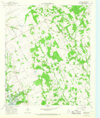
1966 Map of Blanton
USGS Topo · Published 1968About this map
West Prairie dominates the landscape of this central Texas survey, where the rolling agricultural lands of Hill County meet the rising waters of the Whitney Reservoir. The map documents a rural transition as early settlements like Huron and Blanton remain anchored by local landmarks such as Shiloh Ch and Jawbone Cem, while the southern reaches show the emerging recreational influence of Live Oak Resorts along the lakefront. Numerous gravel pits scattered near Aquilla Creek and Little Aquilla Creek indicate the local extraction industry that supported the region's infrastructure during the mid-1960s. The presence of significant pipelines cutting across the terrain further illustrates the industrial modernization occurring alongside traditional farming and ranching operations. For researchers, the map provides a clear record of family-named landmarks like Red Hill and Grub Hill, preserving the names of rural communities before further decades of consolidation.
Find a feature on this map
27 named features on this map. Tap any name to fly to it.
Don’t see what you’re looking for? This feature index may not catch every label — zoom into the map to look around manually.
Map Details
Editions of this 1966 Blanton Map
2 editions found
Other maps of this area

1891 · Cleburne
USGS Topo · 1:125,000

1892 · Waco
USGS Topo · 1:125,000

1894 · Cleburne
USGS Topo · 1:125,000

1920 · Waco
USGS Topo · 1:125,000

1924 · Cleburne 3-B
USGS Topo · 1:48,000

1924 · Waco 2-b
USGS Topo · 1:48,000

1924 · Cleburne 3-C
USGS Topo · 1:48,000

1927 · Blum
USGS Topo · 1:62,500

1931 · Whitney
USGS Topo · 1:62,500

1954 · Dallas
USGS Topo · 1:250,000