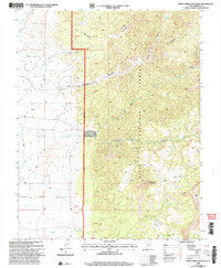
2002 Map of Blind Spring Mountain
USGS Topo · Published 2005About this map
Dixie National Forest dominates this high-altitude landscape, where the Powell Ranger District manages a rugged terrain defined by significant elevation changes. The hydrology of the region is anchored by Sanford Creek, which is fed by the Left Fork Sanford Creek and Right Fork Sanford Creek as they descend from the slopes of Blind Spring Mountain. Evidence of early water management appears in the west with the Old State Ditch, a feature that highlights the historical effort to divert water across the arid basins. To the east, the landscape transitions into unique geological formations such as the Sand Wash Bench and Limekiln Gulch, while high-country water sources like Seed Lakes and Cellar Spring provided essential stopovers for travelers and livestock using the area's network of remote trails and 4WD tracks.
Find a feature on this map
28 named features on this map. Tap any name to fly to it.
Don’t see what you’re looking for? This feature index may not catch every label — zoom into the map to look around manually.
Map Details
Editions of this 2002 Blind Spring Mountain Map
This is the sole edition of this map. No revisions or reprints were ever made.
Other maps of this area

1885 · Beaver
USGS Topo · 1:250,000

1886 · Kanab
USGS Topo · 1:250,000

1953 · Richfield
USGS Topo · 1:250,000

1953 · Cedar City
USGS Topo · 1:250,000

1958 · Richfield
USGS Topo · 1:250,000

1958 · Cedar City
USGS Topo · 1:250,000

1962 · Cedar City
USGS Topo · 1:250,000

1966 · Bull Rush Peak
USGS Topo · 1:24,000

1966 · Fremont Pass
USGS Topo · 1:24,000

1966 · Panguitch NW
USGS Topo · 1:24,000