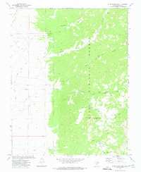
1971 Map of Blind Spring Mtn
USGS Topo · Published 1975About this map
Dixie National Forest dominates this section of Garfield County, where high plateaus and canyons define the drainage patterns of the Sevier River basin. In the early 1970s, this landscape was a network of remote water management and access routes, evidenced by the McEwen Ditch and Old State Ditch cutting across the western flats. The terrain rises sharply toward Blind Spring Mtn, a central landmark surrounded by a complex system of drainage forks, including the Left Fork Sanford Creek and Right Fork Sanford Creek. To the south, the Sand Wash Bench and the isolated Seed Lakes offer a look at the high-elevation geography of the region. This survey captures the intersection of early irrigation infrastructure with the rugged backcountry of the national forest, accessible only by a primitive Blind Spring Jeep Trail and various pack trails.
Find a feature on this map
21 named features on this map. Tap any name to fly to it.
Don’t see what you’re looking for? This feature index may not catch every label — zoom into the map to look around manually.
Map Details
Editions of this 1971 Blind Spring Mtn Map
This is the sole edition of this map. No revisions or reprints were ever made.
Other maps of this area

1885 · Beaver
USGS Topo · 1:250,000

1886 · Kanab
USGS Topo · 1:250,000

1953 · Richfield
USGS Topo · 1:250,000

1953 · Cedar City
USGS Topo · 1:250,000

1958 · Richfield
USGS Topo · 1:250,000

1958 · Cedar City
USGS Topo · 1:250,000

1962 · Cedar City
USGS Topo · 1:250,000

1966 · Bull Rush Peak
USGS Topo · 1:24,000

1966 · Fremont Pass
USGS Topo · 1:24,000

1966 · Panguitch NW
USGS Topo · 1:24,000