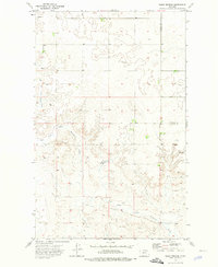
1973 Map of Blink Springs
USGS Topo · Published 1976About this map
Our Saviors Ch stands near the northern edge of this Montana landscape, where the high plains of the Valley and Daniels county line meet. The terrain is defined by the winding course of the East Fork Little Porcupine Creek, which carves through the undulating prairie. Human activity is sparse but telling, centered on agricultural infrastructure and water sources essential for ranching and survival in this arid region.
Find a feature on this map
8 named features on this map. Tap any name to fly to it.
Don’t see what you’re looking for? This feature index may not catch every label — zoom into the map to look around manually.
Map Details
Editions of this 1973 Blink Springs Map
This is the sole edition of this map. No revisions or reprints were ever made.
Other maps of this area

1910 · Todd Lakes
USGS Topo · 1:62,500

1915 · Todd Lakes
USGS Topo · 1:62,500

1915 · Spring Creek
USGS Topo · 1:62,500

1954 · Wolf Point
USGS Topo · 1:250,000

1954 · Glasgow
USGS Topo · 1:250,000

1957 · Glasgow
USGS Topo · 1:250,000

1958 · Wolf Point
USGS Topo · 1:250,000

1958 · Glasgow
USGS Topo · 1:250,000

1973 · Larslan
USGS Topo · 1:24,000

1973 · Larslan NW
USGS Topo · 1:24,000