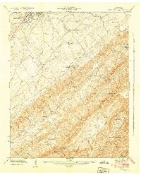
1942 Map of Blockhouse
USGS Topo · Published 1942About this map
Montvale Springs and the village of Blockhouse anchor this 1941 field examination of the Blount County foothills during a period of transition for the region. The landscape is defined by the parallel ridges of Pea Ridge and the massive Chilhowee Mountain, which served as a natural barrier between the agricultural valley and the emerging Great Smoky Mountains National Park. The settlement pattern follows the drainage of Pistol Creek and Ninemile Creek, where numerous small country churches and schools like Law Chapel Sch and Pleasant Hill Ch once served as the social centers for rural families. A notable feature is the Lookout Tower atop Look Rock, providing a strategic vantage point over the Sulphur Knobs. This survey documents several community burial grounds including College Cem and Sixmile Cem, essential landmarks for those tracing local family lineages in the shadow of the Smokies.
Find a feature on this map
63 named features on this map. Tap any name to fly to it.
Don’t see what you’re looking for? This feature index may not catch every label — zoom into the map to look around manually.
Map Details
Editions of this 1942 Blockhouse Map
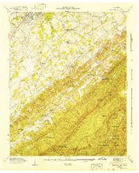
2 editions found
Other maps of this area

1886 · Knoxville
USGS Topo · 1:125,000

1892 · Knoxville
USGS Topo · 1:125,000

1894 · Knoxville
USGS Topo · 1:125,000

1895 · Loudon
USGS Topo · 1:125,000

1895 · Knoxville
USGS Topo · 1:125,000

1901 · Knoxville
USGS Topo · 1:125,000

1935 · Binfield
USGS Topo · 1:24,000

1935 · Knoxville
USGS Topo · 1:48,000

1935 · Maryville
USGS Topo · 1:24,000

1935 · Wildwood
USGS Topo · 1:24,000