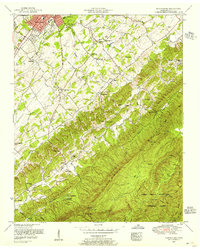
1953 Map of Blockhouse
USGS Topo · Published 1956About this map
The edge of the Great Smoky Mountains National Park meets the expanding southern outskirts of Maryville in this 1953 survey of the Tennessee foothills. This landscape is defined by the heavy ridgelines of Chilhowee Mountain and Sulphur Ridge, where deep hollows like Dillon Hollow Creek and Lynn Hollow Creek create a complex topography. Settlement is concentrated along the valleys, with the historic community of Blockhouse and the resort-tinged area of Montvale Springs serving as local anchors. The map reveals a high density of rural institutions, including the Sam Houston School, Chilhowee View School, and numerous community churches such as Piney Grove Church and Lays Chapel Church. These scattered schools and cemeteries, like Grandview Cemetery and the Sixmile Cemetery, provide a detailed record of the family-centered settlement patterns in Blount County before late-twentieth-century development altered the rural character of the area south of the county seat.
Find a feature on this map
64 named features on this map. Tap any name to fly to it.
Don’t see what you’re looking for? This feature index may not catch every label — zoom into the map to look around manually.
Map Details
Editions of this 1953 Blockhouse Map
2 editions found
Other maps of this area

1886 · Knoxville
USGS Topo · 1:125,000

1892 · Knoxville
USGS Topo · 1:125,000

1894 · Knoxville
USGS Topo · 1:125,000

1895 · Loudon
USGS Topo · 1:125,000

1895 · Knoxville
USGS Topo · 1:125,000

1901 · Knoxville
USGS Topo · 1:125,000

1935 · Binfield
USGS Topo · 1:24,000

1935 · Knoxville
USGS Topo · 1:48,000

1935 · Maryville
USGS Topo · 1:24,000

1935 · Wildwood
USGS Topo · 1:24,000