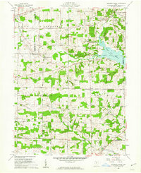
1961 Map of Blooming Grove
USGS Topo · Published 1962About this map
Morrow and Richland counties meet near the emerging Clear Fork Reservoir, which dominates the eastern landscape of this early 1960s survey. The area is defined by a dense network of country roads connecting small settlements like Blooming Grove and Steam Corners. This document reveals the transition from traditional farmstead layouts to a landscape influenced by new water management and recreation, as seen at Camp Avery. Genealogists will find significant value in the numerous well-indexed burial grounds, including Red Squirrel Cem, Haldeman Cem, and Walters Cem, alongside local landmarks like the Townhall and several rural churches such as Pleasant Hill Ch. The northern boundary shows the Erie railroad corridor and the Olentangy River, illustrating the historical transport arteries that once steered development before the reservoir's construction altered the local drainage patterns.
Find a feature on this map
64 named features on this map. Tap any name to fly to it.
Don’t see what you’re looking for? This feature index may not catch every label — zoom into the map to look around manually.
Map Details
Editions of this 1961 Blooming Grove Map
4 editions found
Other maps of this area

1913 · Mount Gilead
USGS Topo · 1:62,500

1915 · Bucyrus
USGS Topo · 1:62,500

1915 · Crestline
USGS Topo · 1:62,500

1915 · Shauck
USGS Topo · 1:62,500

1916 · Mount Gilead
USGS Topo · 1:62,500

1943 · Shauck
USGS Topo · 1:62,500

1943 · Bucyrus
USGS Topo · 1:62,500

1943 · Crestline
USGS Topo · 1:62,500

1943 · Mount Gilead
USGS Topo · 1:62,500

1950 · Marion
USGS Topo · 1:250,000