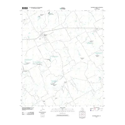
2010 Map of Blooming Grove
USGS Topo · Published 2010About this map
Blooming Grove serves as the primary hub of this north-central Texas landscape, characterized by a complex network of water management features and rural communities. The map highlights the extensive Soil Conservation Service infrastructure, including numerous reservoirs and dams like Soil Conservation Service Site 123 Reservoir and Soil Conservation Service Site 124 Dam, which dictate the local drainage patterns of Rush Creek and Pecan Creek. These systems underscore the agricultural importance of the region, where water retention is critical for the surrounding farmstead operations.
Find a feature on this map
69 named features on this map. Tap any name to fly to it.
Don’t see what you’re looking for? This feature index may not catch every label — zoom into the map to look around manually.
Map Details
Editions of this 2010 Blooming Grove Map
This is the sole edition of this map. No revisions or reprints were ever made.
Other maps of this area

1954 · Dallas
USGS Topo · 1:250,000

1954 · Waco
USGS Topo · 1:250,000

1955 · Waco
USGS Topo · 1:250,000

1956 · Dawson
USGS Topo · 1:24,000

1957 · Irene
USGS Topo · 1:24,000

1958 · Dallas
USGS Topo · 1:250,000

1962 · Emhouse
USGS Topo · 1:24,000

1962 · Cryer Creek
USGS Topo · 1:24,000
1965 · Avalon
USGS Topo · 1:24,000
1965 · Blooming Grove
USGS Topo · 1:24,000